Satellite data has become an important tool that can transform our perspective of Earth and its complex environment. Many space agencies have established dedicated remote sensing programs to use satellite data to monitor weather patterns, track environmental changes, study climate dynamics, manage natural resources, respond to disasters, aid in infrastructure development, and more. Satellite data is also made readily available to the general public, researchers, and various organisations for scientific research and policymaking.
Satellites provide a detailed view of vast geographical areas, but the challenge is to distinguish objects of interest from the background. The presence of cloud cover, shadows, and optical artifacts introduces inconsistencies that further complicate the segmentation. The way to overcome these challenges is to apply a technique called “semantic segmentation,” in which the satellite images are first divided into different regions and a label is assigned to each region, such as “road,” “tree,” or “building.” By training deep learning models on labeled data, it becomes possible to accurately segment and classify different elements in the images.
Yet, when it comes to identifying roads accurately in satellite images, these techniques still need some sharpening. In a recent study, a team from BITS Pilani and Bournemouth University, UK, made a breakthrough in solving this challenge. The team was led by Prof. Trilok Mathur and Prof. Kamlesh Tiwari from BITS Pilani, and included their Ph.D. student, Sugandha Arora. The team’s findings are published in the journal Neural Networks.
Prof. Mathur explains their work: “Our group has been developing fractional calculus-based approaches for modelling various real-life phenomena, and we observed that these approaches can uniquely capture local information”, he says. “Since both local and global cues must be combined during the semantic segmentation of satellite images to accurately extract connected road networks, we augmented typical deep learning models with fractional derivatives using a mathematical technique based on fractional calculus called “fractional optimal control”. In this way, we designed a new and unique road segmentation neural network”.
The proposed technique differs from convolutional neural networks in two ways. First, the fractional optimal control allows for the effective preservation of memory and enables the network to connect road segments accurately, even in obstructed regions. Second, the method uses a weighted sum approach for feature combination, which allows the network to focus on essential features while reducing the impact of irrelevant or noisy information. This is beneficial when segmenting roads in diverse urban landscapes. It also reduces the number of learning parameters for the neural network and ensures the generalisability of the network for new road environments. “As opposed to an automatic way of finding network parameters in deep learning models, which treats the system as a black box, our approach brings explainability using mathematical modelling”, says Prof. Tiwari.
To evaluate the performance of their proposed model, the team conducted tests using two open-source public remote sensing databases: the Massachusetts Road Database (MRD) and the Ottawa Road Database (ORD). These databases contain huge amounts of aerial images covering urban, suburban, and rural regions, so they provided an ideal testbed for assessing the novel model’s performance in road segmentation under various conditions.
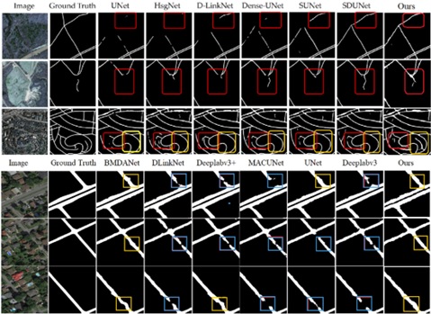
The researchers first trained their model on a subset of images, allowing it to learn and adapt to the data. They then validated the model’s performance on another subset of images to check its accuracy and generalisation capabilities. Finally, they tested its effectiveness on a completely different set of images to ensure a fair assessment of its capabilities. Their findings were incredibly positive. The model produced continuous road networks even in the presence of occlusions like trees and buildings. In fact, it outperformed other state-of-the-art methods!


